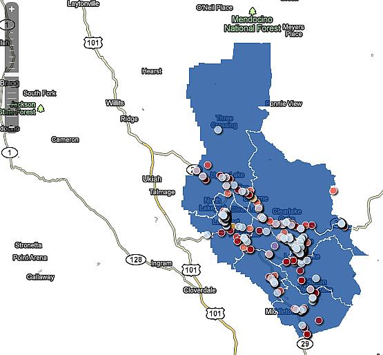
Collision map illustrates county’s high crash rate
This is the fifth installment of a special series on highway safety and its impact on Lake County residents' health.
Part 1: Vehicle crash rates among Lake County's chief health issues
Part 2: Alcohol adds a deadly element to area roadways
Part 3: Many agencies contribute to roadway safety projects, planning
Part 4: Safety projects tackle dangerous highway corridors
Part 5: Collision map illustrates county's high crash rate

LAKE COUNTY, Calif. – The automobile is a fixture of American life, and in rural areas like Lake County’s it’s critical to getting to and from school, work and other commitments.
But for drivers in Lake County, the roadways can be dangerous places.
Over the past week Lake County News has presented this special series, “Hazards Ahead,” in an effort to explore and explain the county’s high number of collisions, listed as a significant health concern in the 2010 Lake County Health Needs Assessment.
Like the needs assessment, state county health rankings have pointed to a growing rate of vehicle crashes, which officials in the course of this series have attributed to many factors – from a roughly 20-percent county growth rate over the past 12 years to alcohol use, difficult rural roadways and distractions behind the wheel.
Seeing is believing, and in an effort to quantify those figures, Lake County News included a mapping component to the series to provide readers a visual of the problem.
Lake County News geocoded information gathered with the assistance of the Lakeport Police Department, Clearlake Police Department and California Highway Patrol to create a map of crashes in Lake County from Jan. 1, 2006, to the present, which is presented here for the first time.
The map, which will be updated regularly and featured as a standalone feature on the Lake County News Web site, is meant to be a tool for residents and visitors to understand crash occurrences on local highway corridors.
It shows approximately 806 crashes, including fatals, injury and noninjury, and hit-and-run, as well as collisions caused by driving under the influence (both drugs and alcohol).
To use the map simply adjust the zoom with the zoom bar at the upper left of the map and select a collision identifier to see the details of the collision.
To view just a particular type of collision deselect the check boxes from other collision types.
For example if you just want to view the 'Fatal Collision Data' deselect the seven other collision data types.
The human equation
Lake County’s health officer, Dr. Karen Tait, said the mapping of hots spots and collision types can be helpful to local health officials and policymakers as a planning tool.
Officials like Tait and Lisa Davey-Bates, executive director of the Lake County/City Area Planning Council, have pointed to Lake County’s rural nature and geography as important factors in assessing and understanding highway safety.
At the same time, the 2010 Lake County Health Needs Assessment and numerous state and federal reports, as well as Lake County News’ own analysis, have shown a high number of crashes on Lake County’s roadways have been caused by drug and alcohol use.
The California Highway Patrol’s Clear Lake Area office, tasked with monitoring safety on local highways and enforcing traffic laws, is studying the problem.
Over the past year, has implemented a “Five Alive” grant, which it reported earlier this month has helped reduce the number of alcohol- and motorcycle-related fatalities on the county’s highways.
At the same time, Caltrans analyzes collision rates, and over the past several years has installed safety improvements in areas along Highway 20 and Highway 29 that have helped reduce crashes.
Similarly, this month Caltrans installed a three-way stop at the intersection of Hartmann Road and Highway 29 in an effort to reduce the number of broadside and fatal collisions that have taken place there at higher-than-average rates.
Within city and county jurisdictions, local road departments continue to aggressively seek grants to make roads safer for all of those who travel them, although they face tougher competition to get funds.
In the day to day work of roads and highways, officials employ a mix of maintenance and planning to try to reduce the numbers of collisions.
Scott De Leon, Lake County’s Public Works director, said that every effort can be taken to make roadways safer, easier to travel and better built. However, that still leaves the human element.
How do officials like him plan to address that critical human factor?
“That’s our biggest challenge,” he said.

